0 ITEMSView cart


This rugged off-road sat nav will show you the way, with navigation for all the places you love to ride.

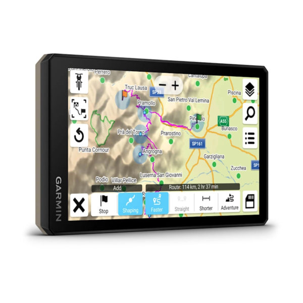
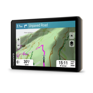
ULTRABRIGHT GLOVE-FRIENDLY 6″ DISPLAY

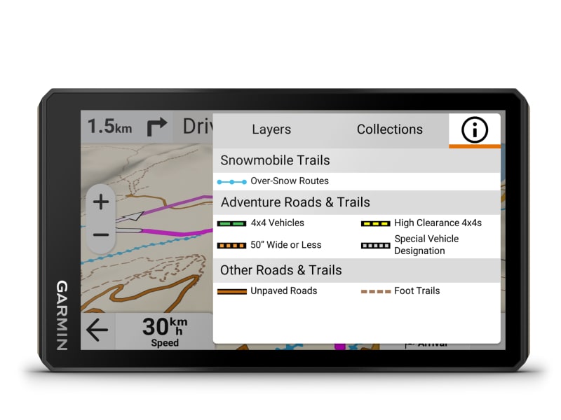
PRELOADED TOPOGRAPHIC MAPS WITH LANDMARKS

BUILT FOR EXTREME WEATHER

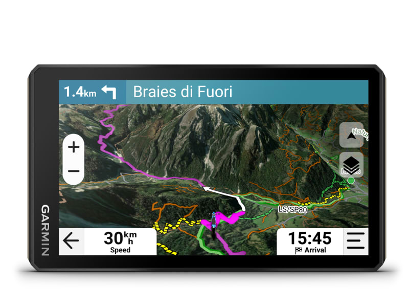
SATELLITE IMAGERY SHOWS VIVID OVERHEAD VIEWS OF YOUR ROUTE

SUPPORTS OUTDOOR MAPS+ FOR PREMIUM MAPPING (SUBSCRIPTION REQUIRED)

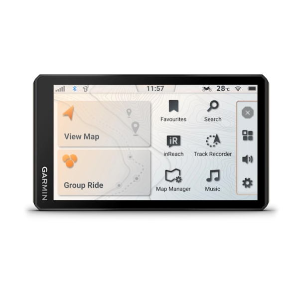
USE THE TREAD APP ON YOUR COMPATIBLE SMARTPHONE FOR EASY ROUTE PLANNING AND MORE


The 6″ high-resolution, ultrabright and glove-friendly touchscreen sat nav is purpose-built to withstand extreme temperatures and weather (IP67 dust / water rating) for rugged off-road adventures. The upgraded processor delivers faster performance, including map drawing and route calculations.
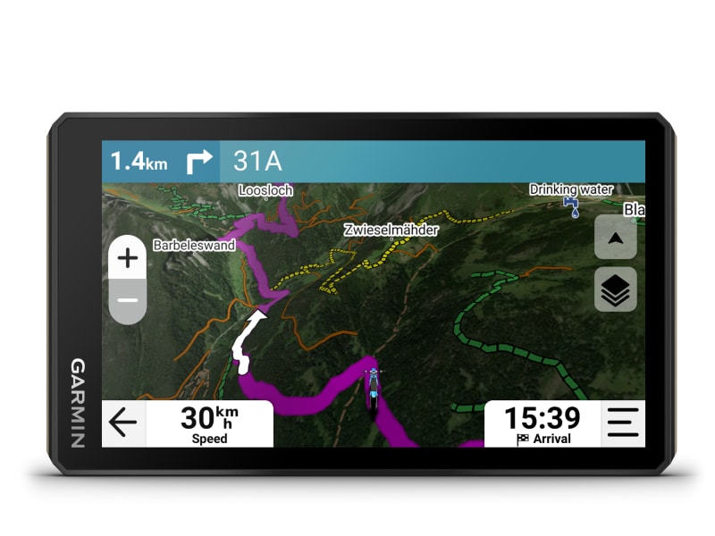
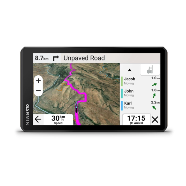
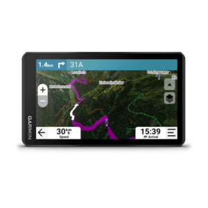
Enjoy turn-by-turn trail navigation for traversing unpaved roads and trails (including snowmobile trails available in Sweden, Finland and Norway) using adventure map content comprised of OSM maps.
Preloaded topographic maps with 3D terrain and street maps for Europe, Africa including Tracks4Africa and Middle East. It also includes the Garmin Adventurous Routing™ option to take the most unpaved roads. North and South America, Australia and New Zealand are available as free downloads via the device map manager.
Download subscription-free satellite imagery directly to the device via Wi-Fi® technology to see high-resolution overhead views of routes and terrain.
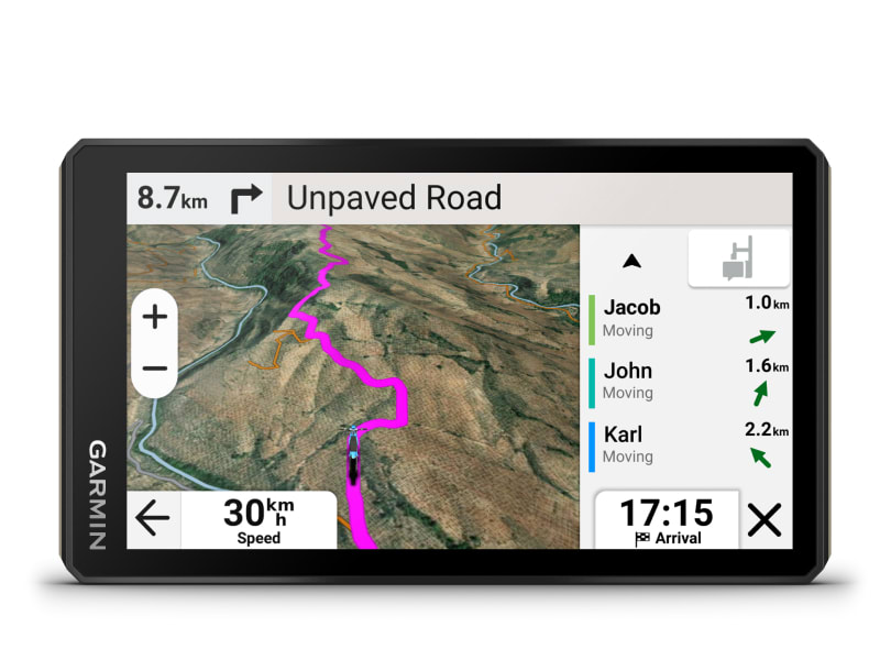
Track friends from your compatible smartphone or Tread device when you and your friends use the Tread® app’s group ride mobile feature.
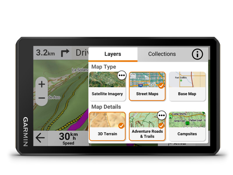
Purchase an Outdoor Maps+ subscription for ongoing access to premium map content, including HD relief shading depicting elevation changes, slope angle, slope aspect, avalanche risk report and more. Learn more about the Outdoor Maps+ content available for Tread devices.


Enjoy detailed street maps of Europe with custom routing for the size and weight of your vehicle2.

Use the Tread mobile app to easily sync waypoints, tracks, routes and collections across your mobile device and Tread 2 sat nav.

For tough-terrain guidance, built-in sensors include an altimeter, barometer, compass and pitch/roll gauges

Easily send GPX files from your phone or third-party sources to your Tread 2 sat nav. Share GPX files with fellow riders by using the Tread app on your compatible smartphone.

Get spoken turn-by-turn directions if you choose to take Tread 2 with you when you head back to civilisation and want street navigation. This includes driver alerts for sharp curves, speed changes and more.

Weather ahead? Pair Tread 2 with your compatible smartphone, and download the Tread app to access live weather, storm alerts, animated radar and more.

Tread 2 comes with a preloaded directory of motorhome or caravan parks and services from ACSI™, Campercontact™ and Trailer’s PARK™

A built-in media player lets you easily control music loaded on your compatible smartphone on the sat nav’s display — and hear your tunes through your helmet or headset enabled with Bluetooth® technology.
Wirelessly pair Tread 2 with your compatible Garmin GPS dog tracker to help track and retrieve your sporting dogs in the field. You’ll see markers for each dog within tracking range, overlaid right on the sat nav’s map screen.

Get critical button control of your map, and keep your hands on the handlebars while riding, when paired with your wired handlebar controller accessory (sold separately).

Pair your Tread 2 off-road sat nav with your compatible inReach global satellite communicator3 for two-way text messaging, interactive SOS and weather.

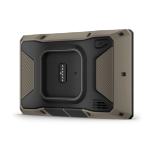
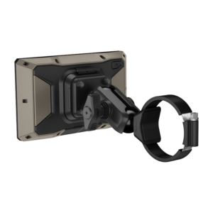
Tread 2 includes rugged roll tube and handlebar mount options to best fit the setup of your off-road vehicle.

When you ride outside of mobile coverage, pair Tread 2 with your Group Ride Tracker for location sharing with your group.

Enable on-screen control for your vehicle’s 12-volt electronics — including light bars, differential locks and more — when paired with your Garmin PowerSwitch digital switch box. Not intended for controlling motors with reverse polarity.

| Series | |
|---|---|
| Activity | Powersport |
| Screen Size | 8 |
| Includes Group Ride Tracker | Yes |
General |
|
| Dimension | 15.6 x 8.9 x 2.5 (6.15″W x 3.5″H x 1″D) |
|---|---|
| Weight | 340 g (12 oz) |
| Water rating | IPX7 |
| Display Type | Multi-touch, glass, high brightness HD colour TFT with white backlight |
| Display Size | 13.3 x 7.5 (5.3″W x 3″ H); 15.3 cm diag (6″) |
| Display Resolution | 1280 x 720 pixels |
| Dual-Orientation Display | |
| Tube mount (1.5″ – 2.375″) | |
| Handlebar mount (up to 1″) | Yes (smaller tube mount) |
| 1″ ball adapter with AMPS plate | |
| Drop rating | MIL-STD-810 |
| Dust rating | IP6X |
| Battery type | Rechargeable lithium-ion |
| Battery life | Up to 7 hours (up to 5 hours at 100% backlight) |
Maps & memory |
|
| Preloaded street maps | |
|---|---|
| High Definition 3D terrain | |
| Data cards | microSD ™ card (not included) |
| 3D Terrain | |
| Internal storage | 64 GB |
| Ability to add maps | |
| Storage and Power Capacity | Yes (256 GB max microSD ™ card) |
| Includes map updates | |
| Downloadable Satellite Imagery | |
| TOPO map support | |
| Downloadable USGS quad sheets | Yes (Outdoor Maps+ Subscription) |
Sensors |
|
| GPS | |
|---|---|
| Galileo | |
| Barometric altimeter | |
| Compass | |
| 10 Hz multi-GNSS positioning | |
Outdoor recreation |
|
| Point-to-point navigation | |
|---|---|
| PRELOADED TOPOGRAPHIC MAPS | |
| Preloaded US public land boundaries | |
| Preloaded private land parcel maps | Yes (parcels greater than 4 acres) |
| Preloaded USFS Roads and Trails, including motor-vehicle-use-maps for motorcycle, ATV, SXS and full-size 4×4 | |
| Navigate-a-track navigation | |
| Turn-by-turn trail navigation | |
| Compatible with Outdoor Maps+ Subscription | |
Camera features |
|
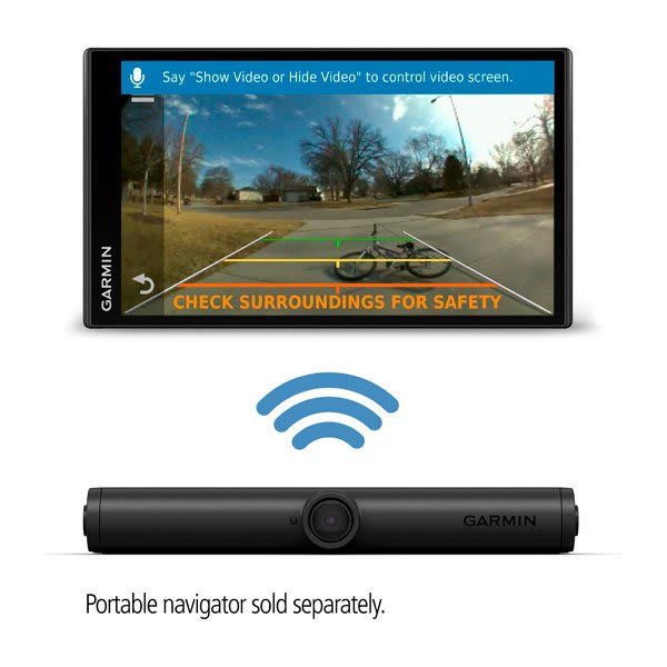
| Backup camera compatible | Yes (BC ™ 50 only) |
|---|---|
Navigation features |
|
| Garmin Real Directions ™ landmark guidance | |
|---|---|
| TripAdvisor ® Traveller Ratings | |
| Route shaping through preferred cities/streets | |
| Traffic Updates | Yes (with Garmin Tread app) |
| Lane assist with junction view (displays junction signs) | |
| Bluetooth ® calling | Yes (works with Bluetooth-compatible helmet, headset or smartphone. BLE capable.) |
| Speed limit indicator (displays speed limit for most major roads) | |
Advanced features |
|
| Smart notifications via app | |
|---|---|
| Wi-Fi ® map and software updates | |
| Access to live services via app | |
Motorcycle features |
|
| Control music and media from smartphone or MP3 player | |
|---|---|
| Sunlight readable and weather resistant | |
| GARMIN ADVENTUROUS ROUTING ™ | |
| Elevation profile | |
| Round trip routing | |
| Custom map support | |
| Wireless ANT+ ® technology | |
Camper Features |
|
| Specialised routing for the size and weight of your vehicle | |
|---|---|
| Speed limit changes | |
| Easy Route Planner with GPX file sharing | |
Adventure features |
|
| Pair with compatible inReach ® devices | |
|---|---|
| Pair with Garmin PowerSwitch ™ digital switch box | |
| Compatible with handlebar controller | |
| Compatible with Group Ride Tracker (6”, 8” and 10”) | |
| Group Ride Mobile | Yes (with Garmin Tread app) |
| Track recorder (breadcrumbs) | |
| Compatible with the Garmin Tread app for route planning and data management (waypoints, tracks, and routes) | |
| ACSI, Campercontact and Trailer’s PARK | |
| Pitch and roll gauges | |
| Birdseye Satellite Imagery (download via Wi-Fi) | |
| Glove-friendly touchscreen | |
Outdoor applications |
|
| Dog tracking | |
|---|---|
Security Information |
|
| Security updates until at least (YYYY-MM-DD) | 2026-11-05 |
|---|---|
BC™ 40 Wireless Backup Camera with License Plate Mount
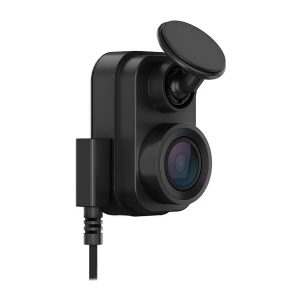
1440p Dash Cam with a 140-degree Field of View
1440p Always-connected LTE Dash Cam with 140-degree Field of View
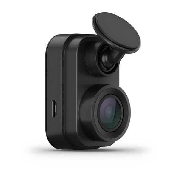
1080p Tiny Dash Cam with a 140-degree Field of View
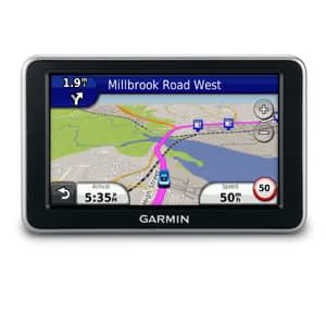

The voice-activated nüvi 2460LT with a large 5-inch screen is easy to use. It’s hands-free...
BC™ 40 Wireless Backup Camera with License Plate Mount
1440p Dash Cam with a 140-degree Field of View
1440p Always-connected LTE Dash Cam with 140-degree Field of View
1080p Tiny Dash Cam with a 140-degree Field of View
The voice-activated nüvi 2460LT with a large 5-inch screen is easy to use. It’s hands-free...
BC™ 40 Wireless Backup Camera with License Plate Mount
1440p Dash Cam with a 140-degree Field of View
1440p Always-connected LTE Dash Cam with 140-degree Field of View